SHASTEEN GENEALOGY
Houston
, TX
 — Updated May 2015
Ray@Shasteen.com
Return to Genealogy Lead Page


 DEEDMAPPER MAPS


These maps were obtained from the Richard Cottrell site — http://www.richardcottrell.org/  — Richard and Mary (Anderson) Cottrell of New Kent Co., VA -  Ancestry and Relation of Richard J. Cottrell

I am using them here pending his approval (site has no contact information) and providing as much credit as I am able.

These are the links for the software: http://www.directlinesoftware.com/pool.htm and http://www.directlinesoftware.com/
 
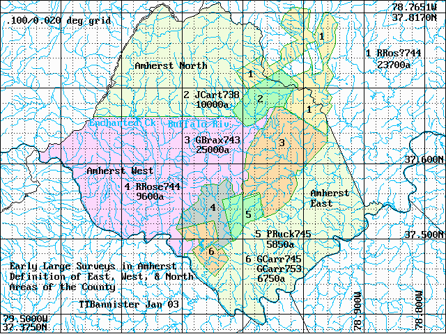
Prof. Thos. Bannister has mapped an incredible amount of our ancestors and neighbors locations. Jas. Shastood is the only listing plotted, however if your Shasteen deeds lists neighbor lines you should be able to line up the their plots on the maps. (using lat/long was able to confirm my speculated location of this property)

http://www.rochester.edu/college/BIO/bannister/index.php?dir=/usr/cwis/data/www-data/college/BIO/bannister/PatentMaps/

Counties with files: Albemarle, Amherst, Appomattox, Bedford, Buckingham, Cabell Lands, Campbell, Chesterfield, Cumberland, Fluvanna, Gallatin KY,
     Ganon Historical Site NY, Goochland , Henrico, James City, Nelson New, Powhatan, Rushford Allegany NY (Included non Virginia with state designation.

DB files are the data files of the original grants or patents - if known, includes latitude/longitude coordinates of the property
GIF files show approximate locations of survey lines
MBL files are to be used in Deedmapper software

Atlas of Early Surveys Lying within the Bounds of Modern Amherst County VA - TTBannister - Jan 2003 (Amherst.txt file from website, highlighting added by me)

Land Office records have been searched for tracts mostly larger than 50 acres, mostly granted prior to 1820, and lying within the boundaries of modern Amherst
County. Modern Amherst lay in Goochland Co until 1749, and in Albemarle until 1761 when old Amherst Co was formed. In 1807 old Amherst was divided into modern
Amherst and Nelson Counties.
Altogether, 996 surveys (or fragments of surveys) have been transcribed and platted, and of these 864 have been located and
mapped.

Between 1738 and 1753, very large tracts were granted to Rev Robert Rose, "late Secy" John Carter, and to Geo Braxton, Peter Rucker, and Geo Carrington. These
tracts cut a broad swathe across what it is now modern Amherst Co (see AmhAll.gif). For convenience in mapping, the remainder of the County is divided
into three districts. Amherst East lies SE of the swathe. Amherst West and Amherst North lie west of the swathe, the west and north districts being divided
by an east-west line centered on Buffalo River and Enchanted Creek of Pedlar River.

Besides this text file, the Atlas consists of .DB, .MBL, and .gif files, for each of the three districts. .gif files provide maps showing the approximate
locations of survey lines). .DB files contain data for each patent or grant (including grantee, year, acreage, brief description, citation, etc). .MBL
files contain bearings and distances of each line of each survey, and are in the format usable by the program DeedMapper.

Locating Surveys

The purpose of the Atlas is to help locate surveys lying in Amherst. There are two ways to proceed. (1) DeedMapper users can use the .MBL files and plat the
individual surveys. Possibly, DM users can solve problems of scaling and longitude-latitude indexing, so that selected surveys can be drawn upon a
background of a gif file map. 2) Alternatively, .DB files may be used to locate a survey. The letter "W", "A", "T", or "U" in column 8 of a .DB file indicates
whether a survey has been well, approximately, or tentatively located or else remains unlocated. If located, columns 9 & 10 give the longitude and latitude
(in thousandths of degrees) at the center point of a rectangle just enclosing the survey lines. Using the longitude-latitude grid of the gif file maps, the
center point can be located. (For those surveys consisting of two or more fragments, the longitude and latitude of the center point is listed for each
fragment.)

Survey Maps - Generalities

Located surveys are drawn with green boundary lines and tinted with colors to make clear the size and shape of the individual tracts. Some later surveys
overlapped earlier surveys; some of these later tracts are drawn with red or purple boundary lines superimposed on the earlier surveys.

In the gif file maps, a few surveys are labelled. Each survey (or fragment of a survey) has a unique 8-character label which is composed as follows: chr 1 is
the initial of the grantees first name, chrs 2-5 are the first four characters of the family name, and characters 6-8 are the year of issuance of patent or
grant. If a survey consists of two or more fragments of lines, chr 5 of each label is a number. If the same grantee received two or more patents in the same
year, chr 4 will be a different number for each grant. In .DB files, the first five characters of a label are listed in column 4, and the year in column 3.

In the maps, a "?" in character 5 of the label indicates the survey consists of two or more fragments.

In the maps, white space sometime indicates mapping errors which leave a gap or an overlap between adjacent surveys sharing common lines. Or white space may
delineate an area where that no survey has as yet been located.

Tagged Stations - Watercourses

The survey records sometimes identify stations as being on or near a named watercourse or road. In transcribing the surveys, these stations are tagged in a
way that permits plotting. Stations on named watercourses have primary use in mapping surveys. The file HYDRO.gif shows that the mapping of surveys has indeed
correctly placed stations on Fluvanna River and Buffalo Rivers, and Porridge Creek, waters which today still retain the same names as in colonial times. In
addition, other tagged stations show the locations of watercourses whose old names no longer appear on modern maps. Examples are Juniper, Stovalls, and
Limekiln Creeks and Mine Branch where a copper mine once existed.

Tagged Stations - Old Roads

File OldRoads.gif shows survey stations on named roads superimposed on a map of modern roads in southeast Amherst Co:

From Lynchburg, old Lynches Road ran due north more or less coincident with modern US 29, then veered off northeasterly on or near modern Coolwell Road (VA
604).

Old Megginsons Road seems to coincide with an eastern stretch of US 60. Study of surveys in Nelson and Buckingham Counties shows that Megginson owned extensive
lands on both side of James River in the vicinities of the modern hamlets of Eldridge Corner and Five Forks. Some stations of surveys in Buckingham Co identify "Megginsons Ferry Road" and point to a ferry near Eldridge Corner. From the ferry, Megginsons Road ran westerly, on the course now followed by US 60,
perhaps extending to the modern town of Amherst.

A line of stations on old Higginbotham Road suggest that this road began near James River near Five Forks and ran northwesterly.

From a point on US 60 about 2/3 of way from Five Forks to Amherst Town, old Dillards Road and Colemans Road seem to have run southeasterly to James River at
or near the modern hamlet of Walkers Ford. Stations of some old surveys in Appomattox County also mention Colemans Road and show Colemans Road trending
toward Walkers Ford.

In Amherst Co, a few stations of old surveys mention Stovals Road (or Stovals old Road). It apparently ran northeasterly-southwesterly about half way between
James River and modern US29.
 

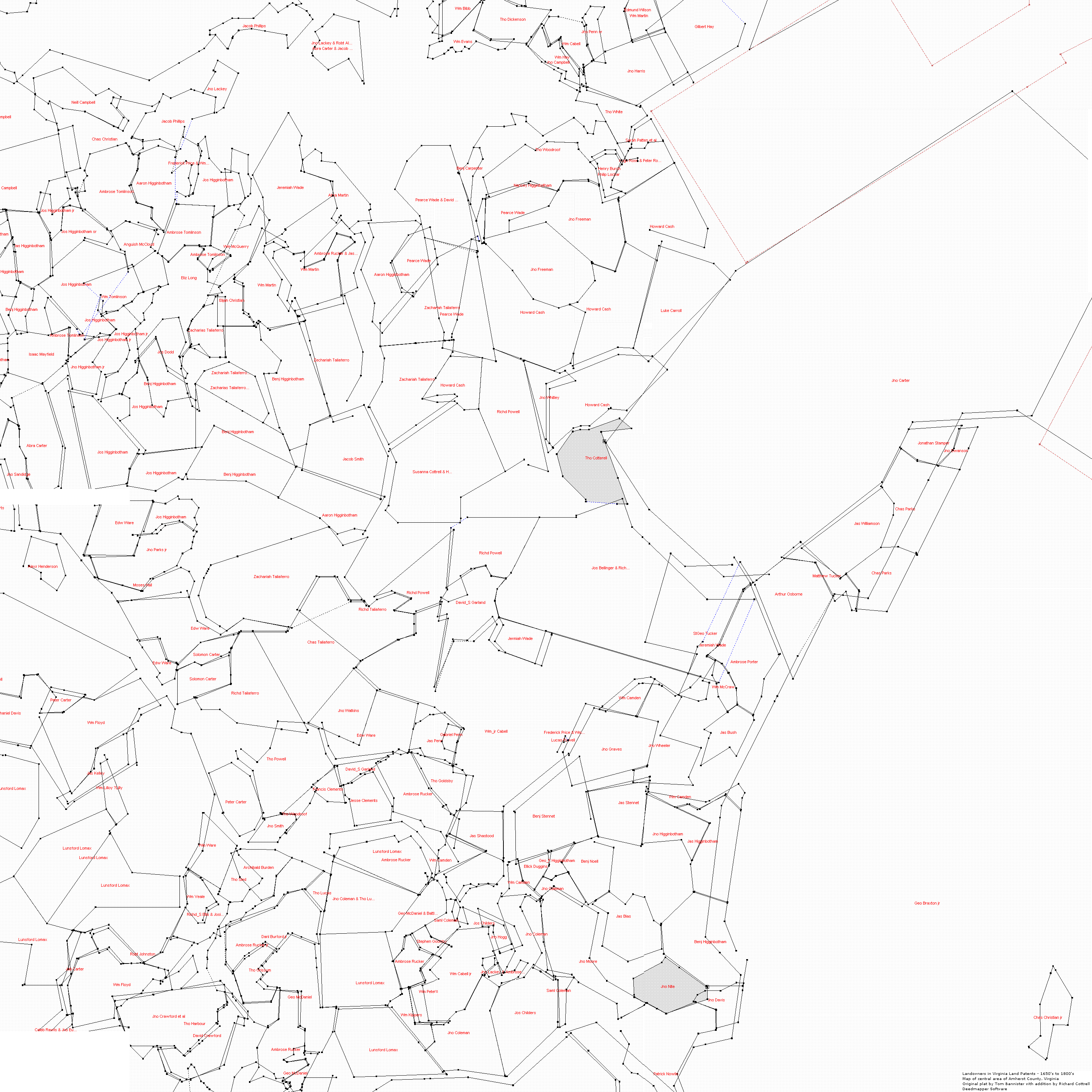
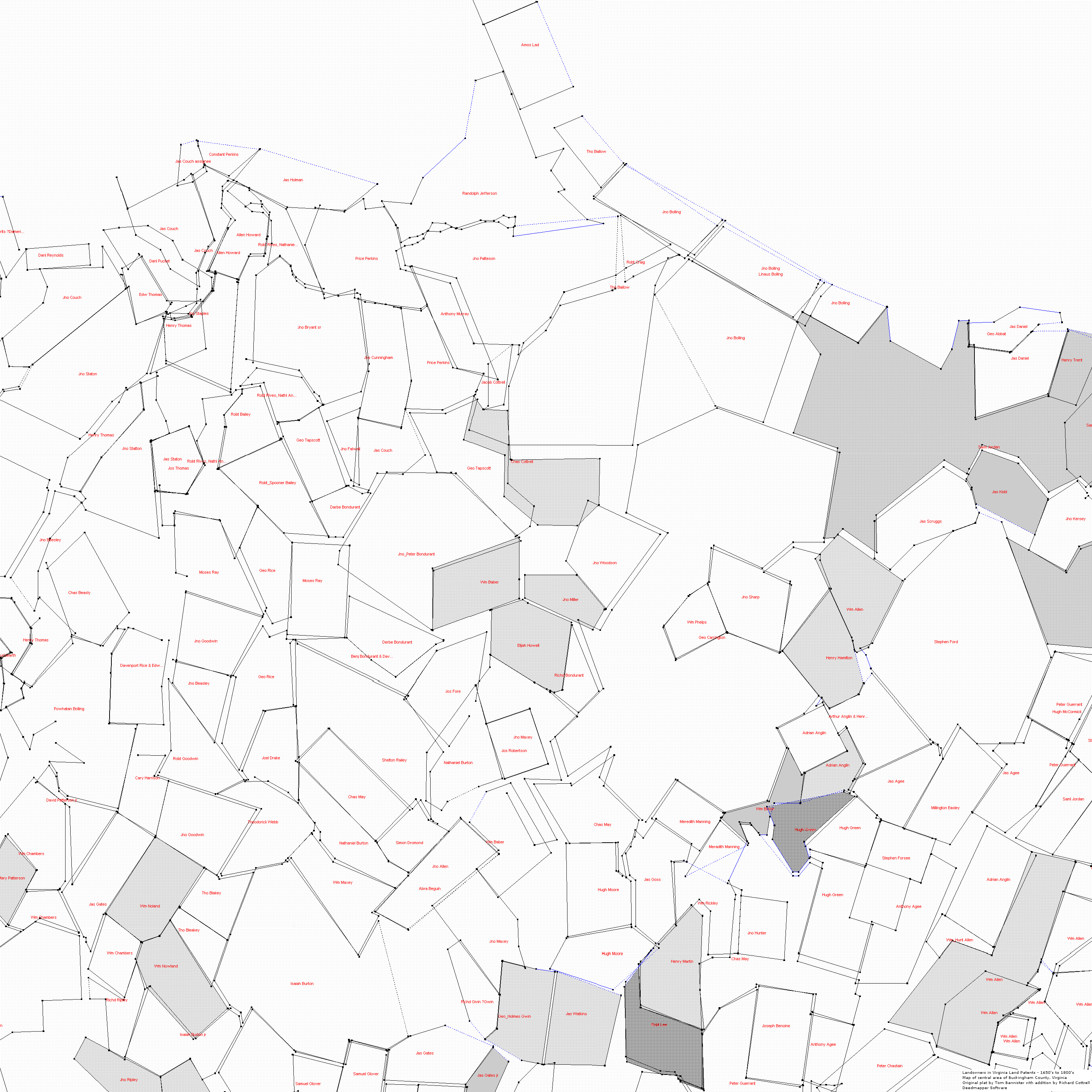
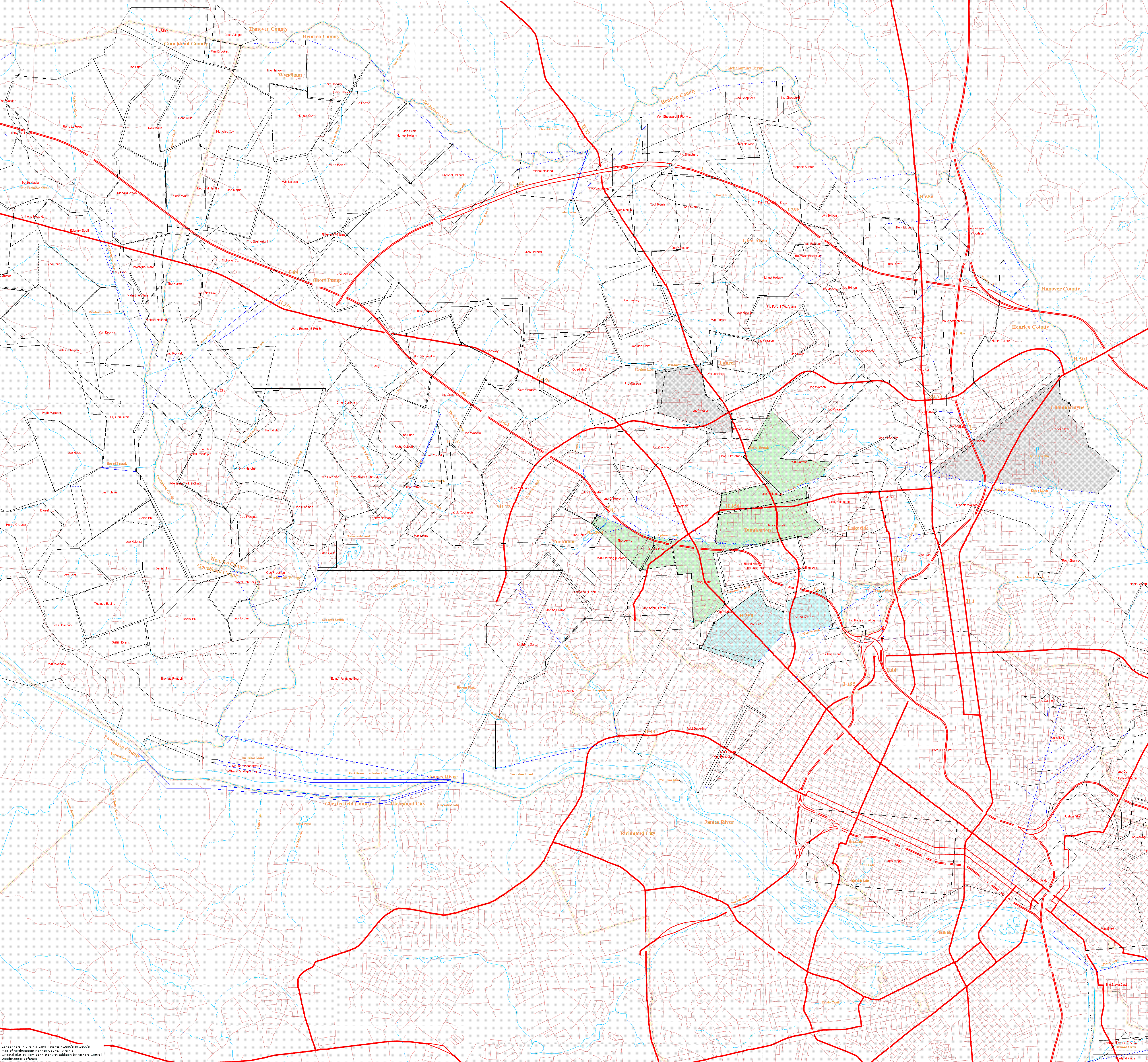
Cottrell Files:
Landowners in  Virginia Land  Patents - 1650's to 1800's,
          Map of central area of Amherst Co VA, Original plat by Tom Bannister with addition by Richard Cottrell using Deedmapper Software
Landowners in  Virginia Land  Patents - 1650's to 1800's,
          Map of central area of Buckingham Co VA, Original plat by Tom Bannister with addition by Richard Cottrell using Deedmapper Software
Landowners in  Virginia Land  Patents - 1650's to 1800's,
          Map of central area of Henrico Co VA, Original plat by Tom Bannister with addition by Richard Cottrell using Deedmapper Software
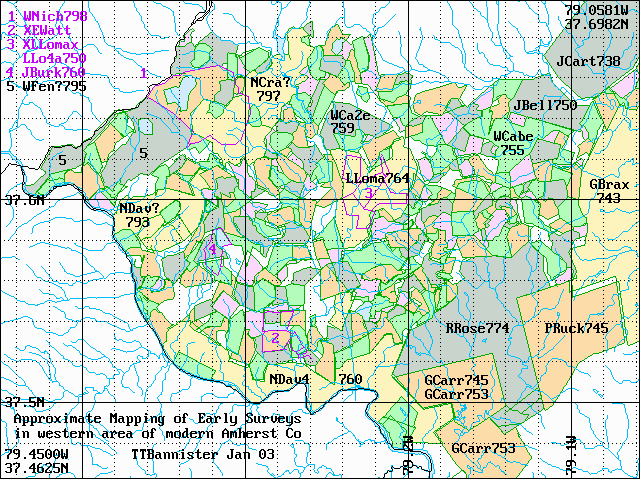
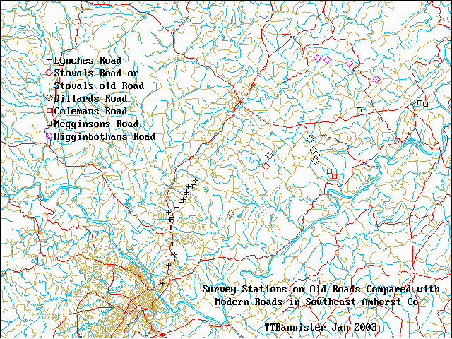
Thomas Bannister Files:
     (Those here copied for personal use with gracious approval of Thomas Bannister)
     Amherst — Explanatory — Databases East, North, West — Maps Amherst All, North, West, Hydro,
Old Roads
     Albemarle — Database

Others, see his site, link above

     Appomattox
     Bedford
     Buckingham
     Cabell Lands
     Campbell
     Chesterfield
     Cumberland
     Fluvanna
     Gallatin KY
     Goochland
     Henrico
     James City
     Nelson New
     Powhatan


Property Owners Listed on Cottrell Deedmapper Amherst Maps
(Listed left to right, top to bottom, three screens, more or less)
 

Amherst Co.
(Note, appears not all property in DB file on map)
Buckingham Co. Henrico Co.
Neill Campbell
Jno Lackey
Jacob Phillips
Chas Christian
Jos Higginbotham Jr
Jos Higginbotham Sr
Jas Higginbotham
Jos Higginbotham
Wm Tomlinson
Ambrose Tomlinson
Aaron Higginbotham
Frederick Price & Wm..
Anguish McCloud
Eliz Long
Wm McQuerry
Wm Martin
Jeremiah Wade
Ambrose Rucker & Jas...
Abra Martin
Pearce Wade
Pearce Wade & David...
Jno Lackey & Robt Al..
Abra Carter & Jacob...
Wm Bibb
Wm Evans
Tho Dickenson
Wm Cabell
Wm Hay
Jno Campbell
Jno Penn Sr
Edmund Wilson
Wm Martin
Jno Harris
Gilbert Hay
Tho White
Benj Carpenter
Tho Woodroff
Nancey Higginbotham
Jno Freeman
Henry Burch
Phillip Lockar
Hugh Rose & Peter Ro..
Sarah Patten et al
Howard Cash

Benj Higginbotham
Isaac Mayfield
Jos Dodd
Benj Higginbotham
Jos Higginbotham
Abra Carter
Jno Sandidge
Elijah Christian
Zacharias Taliaferro
Jacob Smith
Aaron Higginbotham
Howard Cash
Susanna Cottrell & H..
Jno Freeman
Luke Carroll
Richd Powell
Jno Whitley
Tho Cotterell
Jno Carter
Jonathan Stamper
Jno Swanson
Chas Parks

Alexr Henderson
Edw Ware
Jno Parks Jr
Moses Hall
Edw Ware
Nathaniel Davis
Peter Carter
Wm Floyd
Solomon Carter
Rich Taliaferro
Chas Taliaferro
Richd Powell
Jno Watkins
Edw Ware
Richd Taliaferro
Richd Powell
David S Garland
Jos Bellinger & Rich...
Jermiah Wade
Gabriel Penn
Wm Cabell Jr
Frederick Price & Wm..
Lucas Powell
Wm Camden
StGeo Tucker
Jeremiah Wade
Ambrose Porter
Wm McCraw
Jas Bush
Arthur Osborne
Matthew Tucker
Jas Williamson
Chas Parks

Lunsord Lomax
Jas Kelley
Wm Lilloy ?Lilly
Jeb Carter
Wm Floyd
Bobt Johnston
Peter CArter
Wm Ware
Wm Veale
Richd S Ellis & Josi...
Peter Carter
Tho Powell
Tho Woodroff
Jno Smith
Archibald Burden
Tho Sled
Danl Burford Jr
Ambrose Rucker
Tho Grissum
Geo McDaniel
Francis Clements
David S Garland
Jesse Clements
Tho Goldsby
Wm Camden
Tho Lucas
Jno Coleman & Tho Lu
Wm Peters
Stephen Goolsby
Wm Cabell Jr
Saml Coleman
Geo McDaniel & Battl..
Tho Goldsby
Wm Camden
Jas Shastood
Benj Stennet
Jno Graves
Jno Wheeler
Wm Camden
Jno Higginbotham
Jas Higginbotham
Jos Childers
Jno Hogg
Jno Lackey & Ambrose..
Jno Coleman
Ellick Duggins
Geo Higginbotham
Benj Noell
Saml Coleman
Jno Moore
Jas Bias
Jno Nite
Benj Higginbotham
Jas Higginbotham
Jno Higginbotham
Wm Camden

Caleb Rawls & Jon Eu..
Jno Crawford et al
Tho Harbour
David Crawford
Ambrose Rucker
Wm Kippers
Wm Peters
Jno Coleman
Wm Peters
Jno Coleman
Jos Childers
Saml Coleman
Patrick Nowlin
Jno Davis


Key Properties from Amherst West DB files


Name            YR                   Ac. County
              (1749)

Lon / Lat for Google Maps

Shastood Jas    749 JSHAS P-28-571-1 150 Albema W 79143 37609 XHUFF  hd brs Huffs Ck on s TobaccoRow Mt
  (Significant as this confirms location of Shastood grant)
Gatewood Ambros 791 AGATE G-24-408-1 400 Amhers W 79342 37567 XAGATE bs Otter Ck
  (Significant as this confirms Shastead Otter Creek property)
Ellis Richd_    806 RELLI G-55-454-1  50 Amhers W 79321 37596 XAGATE bs Otter Ck
Ellis Richd_    808 RELLI G-57-354-1  20 Amhers W 79323 37598 XAGATE bs Otter Ck
  (Significant as this confirms Shastead Otter Creek property)
Nowlin Jas      780 JNOWL P--E-299-1 279 Amhers A 79355 37555 XDGARL N s & on Fluvanna Riv
  (Significant as this confirms Shastead Otter Creek property)
Burford Danl    771 DBURF P-40-470-1 300 Amhers A 79183 37595 XGMCDA2 S brs Harris Ck
  (Not significant, thought might lead to Burford road)
Waugh Jas       782 JWAUG G--G-240-2 280 Amhers W 79351 37536 XNDAV85B N s & on Fluvanna
  (Maybe significant, could indicate location of Thomas Waugh property in 1806 Rule Order Book location of the bridle path)
Bias Jas        771 JBIAS P-40-476-1 230 Amhers W 79115 37596 XHUFF brs of S fk of Huffs Ck
  (Significant as may help clarify identity of James Shasteen via relationships with John and Obed Byas(Bias)
Davis Wm 809 WDAVI G-60--64-1 100 Amhers A 79366 37563 XDGARL wo Otter Ck on Fluvanna Run


37.609 -79.143
(
.
(
.
.
(
37.555 -79.355
(
37.595 -79.183
(
37.536 -79.351
(
(
37.596 -79.115

37.563 -79.366


Key Properties from Nelson North DB file


Name                YR                   Ac. County
                 (1743)

Lon / Lat for Google Maps

Wade       Jno    743 JWADE P-21-589-1   300 Goochl T 78926 37866 XWMORR   brs Rockfish Riv
  (Significant as this is part of the land sold by Jesse Shasteen and wife Eleanor Wade Coffee Shasteen)
37.866 -78.926
(


Copyright © 1995-2015, All rights reserved