MAP — AMHERST CO., VA
![]()
MAP — AMHERST
CO., VA
![]()
The purpose of this map is to identify specific
landmarks in Amherst County that relate to research particularly of deeds,
wills, etc.
It is intentionally large to fill your monitor and high resolution to facilitate
reading. You may be able to enlarge depending upon your software. It is
about a 3 meg file.
Landmarks indicated below.
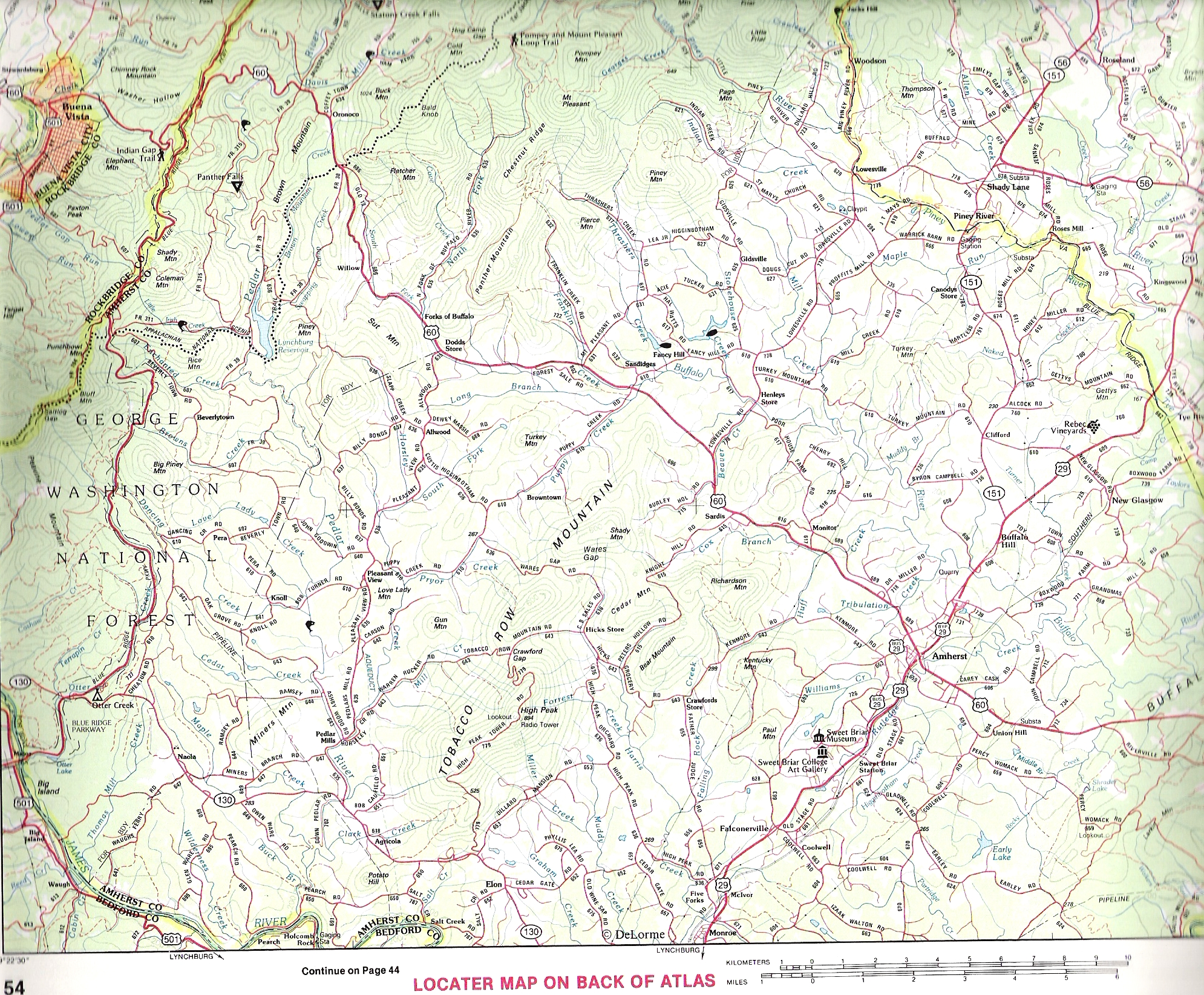
— Map_AmherstVA.doc , download this doc file if you see no reference points on the map. —
|
Ref Num |
Map Ref |
Location and Description Ref Num = Green box, red number — Ref Ltr = Turquoise box red letter |
Ref Ltr |
Comments |
| 1 | City of Amherst - Follow Hwy 29 from above the work Atlas N to Hwy 60 | General Reference | ||
| Bedford Co bottom of page, Rockbridge to the left and above, Nelson Co to the right and above - Note yellow tinting of county lines | My Shasteen line in Rockbridge and Amherst Cos. | |||
| .5A—1 | Pisgah Hill, Rockbridge Co- Off of map to the top left | Don't remember significance. | ||
| 2 | D —0.8 |
Otter Creek, Amherst Co - Blue
Ridge Parkway follows Otter Creek from Hwy 501 in the lower left corner.
Note Otter Lake also. I suspect the Otter Creek property to be closer to the James River rather than father away to have sufficient flow to power a mill, so I have indicated that on the map with the placement of the C letter nearer the James River. |
B C C C |
Referred to in Nov 1751 Sharstead, James 150 acres to Wm Cabell Huff's Creek East side of Tobacco Row Mountains 17 Jun 1799 Shastead (& Shattead), James 100 A from Ambrose Gatewood, Sr on Otter Creek 15 May 1812 James Shastead, Sen 130A to John & R.S. Ellis Both sides Otter Creek and the mill and all the premises (Never found purchase) 14 Sep 1812 Shartead James, Jr. & wife Phoebe 100A to John & R.S. Ellis et al - Both sides of Otter Creek |
| 3 | D — 2 | Tobacco Row Mountain, Amherst Co - Directly above the word locater | B | Nov 1751 Sharstead, James 150 acres to Wm Cabell Huff's Creek East side of Tobacco Row Mountains |
| 4 | C 0.8 — 2.5 | Huff Creek, Amherst Co - about 3 miles W NW of Amherst | ||
| 5 | C — 3.5 | Buffalo Creek, Amherst Co - NE of Mountain in Tobacco Row Mountain | Buffalo was used as a designation for one of the James Shasteen's in the Amherst Tax roles in 1791-1792 | |
|
6 7 |
D — 1.5 |
Pedlar Mills, Amherst Co - About 4 miles above the word Continue at the
bottom of the map. Pedlar Creek appears to start at point 7 and run down to point 6. |
Pedlar was used as a designation for one of the James Shasteen's in the Amherst Tax roles in 1787-1790. This designation could cover 8-10 miles from point 7 on the map down to point 6. | |
| A | Aug 1748 Sharstead, James witness, sale of 580 A from John Thrasher to James Smith | |||
| D | 13 Apr 1789 Shasteen, Jesse, wife Elinor and Elizabeth Wade to Jacob Puckett for 35£, recorded in 1789 in land tax alterations North fork of Davises Creek, formerly owned by John Wade...James Cull's line...William Allen's part...Archibald Coffey's (Jesse married his widow Elinor) (Note proximity of Davis Creek and Coffey Town on the current map) |
![]()
![]()
![]()
![]()
![]()
![]()
![]()
![]()
![]()
![]()
![]()
![]()
Copyright © 1995-2014, All rights reserved